ERSC Banner Logo and link to home

Home :: EOI :: SSEC :: LakeSat :: WisconsinView :: About :: Archives

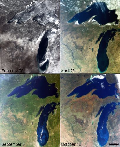
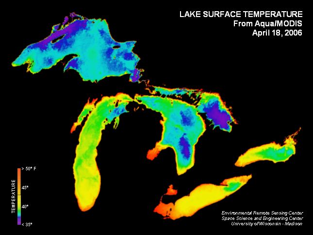
Past ERSC News Items

  • The Wisconsin Idea and Sam Batzli of WisconsinView Listen in or download the podcast on Milwaukee Public Radio's "Lake Effect" May 14 program.

    Click here
    to watch
    via Wisconsin Public Television's "Here and Now" of 4/18/08


    Director cultivates a mile-high appreciation of Wisconsin
    Read the Profile of 4/18/08
    Batzli is the director of WisconsinView, a federally funded program that offers a free Web service for easy access to a variety of statewide images and data. “We basically provide a shortcut,” Batzli says. “WisconsinView offers free access to public domain data sets that would otherwise be difficult or expensive to acquire.”
  • The Magic and Meaning of GPS can be heard in a 30 min. broadcast on WORT Radio's Perpetual Notion Machine of 4/3/08 with guest Dr. Tim Olsen, from UW's Space Science and Engineering Center
  • Images of California Fires Sharpens Focus on Loss of Satellites Watch the CNN Story of 10/25/07

    Satellite woes raise concern
    2:04
    Critics say losing Earth-watching sensors endangers the ability to track natural disasters. CNN's Miles O'Brien reports
  • View of California fires from Aqua MODIS satellite at 4:00 pm local time, 10/22/07
    View from Aqua MODIS satellite at 4:00 pm local time, 10/22/07

    Acquired by direct broadcast and processed at the UW's Space Science and Engineering Center (SSEC)
  • Destruction from the Wisconsin Tornado Outbreak of June 7th, 2007 is visible in satellite imagery processed at ERSC. An F3 tornado cut a swath of destruction approximately 35 miles (56km) long and in places nearly 1/2 a mile wide (800m) from Menominee County across southeastern Langlade and northern Oconto Counties. Clear skies on June 9th made it possible to see the destruction swath in imagery collected by the MODIS sensor on both the Terra (12:28pm) and Aqua (2:09pm) satellite overpasses. -- Sam Batzli June 9, 2007

    NOAA's National Weather Service page June 8, 2007
    NASA's Earth Observatory page June 11, 2007
    SSEC's Spotlight page
    SSEC-ERSC's Tornado page
    Imagery Downloads: WisconsinView.org

    Ecosystem Services  Map screenshot
    Daily imagery of Wisconsin is routinely colleted and processed here at the Space Science & Engineering Center at the University of Wisconsin-Madison and can be viewed through ERSC MODIS ImageServer or our Direct Broadcast site.
  • ERSC Web-mapping services support Conservation International. By using Open Geospatial Consortium standards for WMS (web mapping services), ERSC is publishing data layers that enable a web mapping project at Conservation International. The site showcases collaborative conservation case studies in an interactive web-map facilitated by the Google Maps API and MapServer technology. Puneet Kishor developed the site with contributions from Sam Batzli at ERSC-SSEC and others.

    Ecosystem Services  Map screenshot
    The interactive map allows users to pan, zoom, turn on/off layers, and even contribute case study information.
  • The Lake Shore Preserve website has won a national award from the Association of American Geographers (AAG). The award committee reported that "The preserve website combines outstanding design with text, photographs, an interactive map... [where] viewers can compare aerial photographs of the preserve from 1927 through 2004."

    Preserve Map screenshot
    The historical aerial imagery used in the map was initially scanned, rectified, and processed by Sam Batzli at SSEC-ERSC.
  • Satellite images from ERSC are included in a new exhibit of historical maps of the Great Lakes region. The exhibit traces the development of cartography in the region from the 17th Century to the present. Three of the maps developed by Jon Chipman (nos. 26, 28, and 29) explore the use of satellite remote sensing in maps. The exhibit is on display through June 29th at UW-Madison's Memorial Library.

    UW News Release 03/21/07: Exhibit traces 300 years of Wisconsin and Great Lakes maps

    The exhibit, "Making Maps, Mapping History" includes more than 30 original maps illustratrating the evolution of mapmaking since the 1600s and the influence of the Great Lakes on the region's history. An audio tour is also available, with recorded commentary about the maps.
  • It's Official! The Environmental Remote Sensing Center is now part of the Space Science & Engineering Center (SSEC) of the UW Graduate School. Here is the official UW Press Release. We are excited about the future as we begin to explore the collaborative potential of this venture!

    UW News Release 01/09/07: BRINGING TOGETHER THE STUDY OF THE EARTH AND SKY

    Click for larger image At approximately 3pm on December 12, 2006 during the opening of the Annual State of SSEC address, Director Hank Revercomb (left) called upon Graduate School Dean Martin Cadwallader to sign the official papers.
  • EarthIT (Earth Information Technologies Corp.), is featured in the Wisconsin Technology Network news. Started just 7 years ago by then Environmental Monitoring students Marek Dudka and Dan Rooney, Ph.D., it now employs 25 full time scientists, engineers, designers and programmers.
  • Changes for EM:

    The Environmental Monitoring Graduate Program: The Nelson Institute has temporarily suspended admissions to the EM Program beginning Fall 2006 pending the results of a campus-level planning process. If you have questions about this, please contact SIAC task force members A-Xing Zhu and Steve Ventura.
  • ERSC awarded 1/2 million dollar NASA grant to study lakes worldwide. Researchers at ERSC will undertake a new three-year project to track changing water storage and water quality in some of the world's largest and most dynamic lakes, scattered across six continents. Lead by PI Jon Chipman, The team will use a multisensor approach to measure water levels, changing surface areas, and in-lake conditions such as water clarity.
  • EPA Newsletter covers Wisconsin lake water quality research. The article ("Satellite Data Open a New View on Water Quality", pp. 18-21) is in the August 2005 issue of Nonpoint Source News-Notes (2 MB pdf), and includes extensive reporting on ERSC's Landsat-based assessment of lake water clarity statewide.
  • Tornado Tracks from 2005's record-breaking August 18 Wisconsin Outbreak were detected and enhanced by the ERSC team using diverse satellite instruments. Geo-referenced data downloads for Emergency Management professionals are available via our WisconsinView downloads portal. Stoughton, Viola and Spring Green tornado tracks are all viewable.
  • Retiring UW Environmental Monitoring Professors to be honored. On Saturday, May 20th, the University of Wisconsin-Madison will honor Drs. Thomas Lillesand, Frank Scarpace and Alan Vonderohe for their nearly 90 years of combined service to the University and for their greater contributions to the field of geospatial science. All three plan to retire from the UW at the end of the spring 2006 semester. The professional community will pay tribute to them with an afternoon symposium (1-5 PM), evening reception and dinner banquet (5-9:30) at the Pyle Center on the UW-Madison Campus. (more info).
  • ERSC demonstrates Google Maps' recently published API (Applications Program Interface). The JavaScript API provides a set of routines, protocols, and tools for imbedding and customizing Google maps such as this ERSC example. Recent articles in the New York Times (article 1 - requires login; article 2 - abstract only) and elsewhere point to geospatial webservices as the largest future growth area of the internet. (note: works best with Firefox or Safari)
  • More than Pretty Pictures: satellite remote sensing proves to be a powerful component of environmental monitoring, analysis, and policy development. The sharp increase in its use by the news media following events such as Katrina and popular applications such as Google Earth and World Wind demonstrate that geospatial information technology (IT) is indeed experiencing an unprecedented global growth swing. See: NYT Article on New Orleans wetlands. Also DigitalGlobe, SpaceImaging, and SKYTRUTH public imagery of Katrina's aftermath.
  • Waertown tire fire smoke plume visible by satellite. On July 19, 2005 the ERSC MODIS ImagerServer captured imagery of the enormous smoke plume generated by a raging fire at a Watertown, WI recycling facility. Click here for images and technical discussion or for the UW press release.
  • New atlas uses historical satellite imagery to track the dramatic, damaging environmental changes sweeping planet Earth. Produced by UNEP (United Nations Environmental Programme), "One Planet Many People: Atlas of our Changing Environment" compares and contrasts spectacular satellite images of the past few decades with contemporary ones.
  • Satellite remote sensing of lakes is progressing at ERSC with a recent WDNR technology transfer session and new field spectroradiometry information and data on our UW SeaGrant funded LakeSat.org website.
  • Satellites used to measure and record the recent tsunami in the Indian Ocean. This Associated Press news article describes radar work. View images from SpaceImaging tsunami gallery and DigitalGlobe tsunami gallery.
  • ERSC launched its new ArcIMS 9 website with RH Linux 3 AS on Friday, October 8, 2004. Try the new CampusMap website example. Or try these webservice examples: Wisconsin MODIS seasons || shaded relief || CampusMap on MODIS.
  • EM students Garcia and Kelley teamed up with geography student Newman to develop an online interactive map of the Campus Natural Areas (CNA) for Geography 575 in the Spring of 2004. The map is now entered in the NACIS web map competition (requires Flash browser plugin).
  • The ERSC MODIS ImageServer processed and archived its 1000th image on June 4, 2004 with the 12:04 pm Terra pass. Our ImageServer has been in near continuous operation since October 2002. Read an academic article about our processing system.
  • MapTEACH, a National Science Foundation place-based geospatial learning program for schools in rural Alaska is underway. Visit our website at http://mapteach.org.
  • March 26, "WisconsinView," a planned statewide remote sensing and geospatial data access and distribution node led by ERSC and the State Cartographer's Office is a new full member of the AmericaView Inc. consortium.
  • US Department of Labor "Career Voyages" identifies "Geospatial Technology" as one of the three emerging career areas with "the hottest occupations in the U.S. with the fastest growth rate and the most job openings." (web site) (geospatial.pdf)
  • ERSC and Lillesand cited in January 22 Nature (web version) (pdf version) article about careers and jobs in the GIS and remote sensing industry.
Skip links bar.
Skip address and contacts.
Environmental Remote Sensing at the Space Science & Engineering Center :: University of Wisconsin-Madison
1225 W Dayton St, Floor 12 :: Madison, WI 53706
Website Questions: Sam Batzli :: Administrative Questions: Steve Ventura
ERSC Logo and Link       UW-Madison Logo and Link      SSEC Logo and Link